Flora of Georgia and surrounding states
This is a site under serious construction and for now contains mostly random content and images based upon my momentary interests.
Plants and Geography
The plants on these pages that I include are based solely upon the areas that I frequent.
Let me first make the obvious statement that plants have no knowledge of, nor do they recognize, state borders. So on the face of it, to create a catalog of all the plants of any state is an entirely artificial endeavor. Now, this has been done many times, all over the world. This is because humans have knowledge of, and recognize, political borders. From our point of view it makes some sense, mostly convenience. From the plant's point of view (if they had one) it makes no sense.
Let me first make the obvious statement that plants have no knowledge of, nor do they recognize, state borders. So on the face of it, to create a catalog of all the plants of any state is an entirely artificial endeavor. Now, this has been done many times, all over the world. This is because humans have knowledge of, and recognize, political borders. From our point of view it makes some sense, mostly convenience. From the plant's point of view (if they had one) it makes no sense.

|
To illustrate this point, When Alan Weakley began work on a new flora to update the 1968 Manual of the Vascular Flora of the Carolinas which covered only North and South Carolina, he followed suit. Soon after, he added Virginia. Then Georgia. Then "surrounding areas" got added like the coastal plain of New Jersey and the Panhandle of Florida. The last area added is that east of the Mississippi River south of Lake Pontchartrain in Louisiana. This "geographic creep" (his own term) of expanding coverage comes from areas with similar plants. When he added Georgia, the number of pages actually got smaller as the many notations about Georgia range extensions were eliminated! The Carolinas, Virginia and Georgia are defined by man-made borders.
Left is the coverage map of the 2012 edition of Alan's Flora of the Southern and Mid-Atlantic States.There are now only three geometric line political borders, all contiguous. From East to West they begin at the Delaware River on the "12-Mile Circle" to that point where it intersects the Mason-Dixon line and follows it to the western border of Pennsylvania (five degrees of longitude from where the Mason-Dixon Line would have intersected the Delaware River), following it north to the Ohio River. From here the coverage follows the Ohio River to the Mississippi River out into the Gulf of Mexico. His delimitation in Florida is the Panhandle and the northern bordering counties with Georgia. |
The shading represents physiographic provinces with pale cream the Coastal Plain; pale gray the Piedmont; deep gray the Blue Ridge and medium gray the Cumberland Plateau).
This very illuminating map below from the Biota of North America proves the point and supports Alan's "creep". Deep blue indicates an area with 95 to 100% similarity with Weakley's Flora. As the colors move to red, there is decrease in similarity to only a 0 to 5%. The area of deep blue is not very different than his coverage map. It may turn out he "creeps" into all the areas that are deep blue!
A big note to be added to this is the fact that this is based upon county records and plants don't recognize county borders any more than state borders, but there are way more counties than states which provides a great deal more resolution.
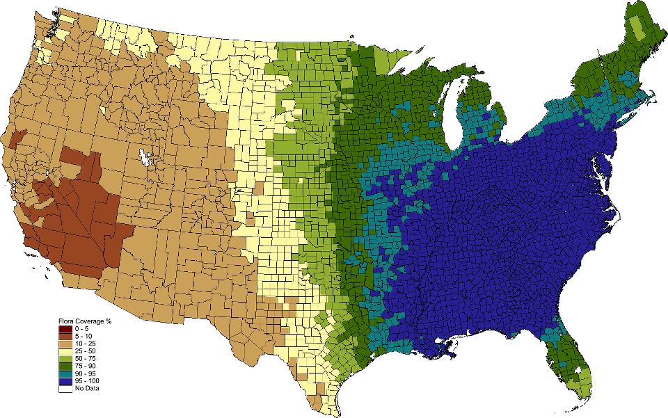
Beyond state boundaries, it is also obvious that the Ohio and Mississippi Rivers are not a boundary for plants either. However, note the deep blue does not extend greatly west of the Mississippi River. Just why might this be?

|
When I compare this USGS map of Annual Precipitation to both maps above and and a couple of fairly obvious things strikes me:
Geography here shows that the Ohio-Mississippi River traces—while natural—are almost as arbitrary as the geo-political lines as plants clearly cross the rivers. Rainfall trumps them all. The southeast is a wet place and the flora that developed here is well-watered. |

|
John Wesley Powell greatly slowed the development of the western states with his 1879 Report on the Lands of the Arid Region of the United States, with a more detailed account of the Lands of Utah, as it described the west as the "Arid Region". He defined "...the eastern boundary of the Arid Region ... in a general way it may be represented by the one hundredth meridian..." and since publication, this has been coined "the line of semi-aridity".
Anyone who has flown across the breadth of the United States and looked out the window from 35,000 feet has seen this. East of this line there is little to no irrigation. West of this line there is extensive—and required—irrigation. Compare the map to the left from his report with the Biota of North America above map the close correlation with plants is more than striking. For our southeastern flora, water trumps all! |
Widely Distributed Plants

Cranefly orchid, Tipularia discolor (Pursh) Nuttall, is probably the most common orchid in North America. In Georgia, it has been found in all of our 159 counties and thus was chosen as the name of the journal of the Georgia Botanical Society. There is hardly a field trip where we can't find at least one (and usually many more) of this nearly ubiquitous plant.
While each plant may have a dozen or more flowers on a stalk that stands a foot or more tall, the mauve-green color blends so well with the forest floor background that the plant is easily overlooked. I takes a practiced eye to be able to spot them when they arise, leafless, from the duff in late July to September. Their single overwintering leaf is much easier to spot, especially when turned over to expose the deep purple underside.
The genus name is derived from Tipula, the genus of crane-flies, from its fanciful resemblance. This photo illustrates a single flower with its three petal-like sepals, two petal-like petals and a very long lip or spur where the nectary is. All orchid flowers are inferior, with the fruit developing well below the flower, seen here as the lined swelling below the flower and above the singly twisted flower stem.
Spring Ephemerals

Bloodroot, Sanguinaria canadensis Linnæus, is a great representative of the flowers that erupt in early spring and only delight the eye and mind for a short while before they wither and disappear under the duff. Each year I continue to take photographs of this flower and must have hundreds. I'm never pleased with my results and so early each spring head off to Kennesaw Mountain in late February and early March to find another flower to try again.
The plant gets both its common and generic name from the underground rhizomes. When a thin slice is taken, it bleeds a red liquid that strongly resembles blood from a thin cut into human skin. Please don't dig one up to try this as you'll destroy that plant forever!
While the plant has a long history of ethnobotanical and homeopathic use, it contains the poisonous alkaloid sanguinarine that interferes with cell membrane proteins and kills cells. When used as a salve on the skin, it can result in severe scarring. The plant is best enjoyed as an especially beautiful sign of winter breaking. It is hard to imagine a more pure white than the petals of the first bloodroot of spring.