Geology of Kennesaw Mountain, amphibolite, Hurst, 1956
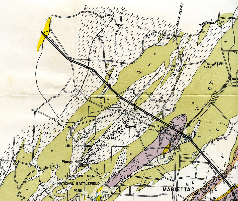
Kennesaw Mountain section of Hurst's 1956 geologic map
Legend
Metaigneous Rocks pale green ar Amphibolitic rocks (dominantly hornblende gneiss)
Migmatites white with Y's Kg Kennesaw gneiss
Metasediments purple gms Garnet-mica schist
Hurst, V. J. 1956. Geologic map of Kennesaw Mtn-Sweat Mtn area, Cobb County, Georgia. [The map is often referenced with Mtn spelled out and with "Map RM-13. Georgia Geologic Survey, Atlanta, Georgia" added, but these are not found on the actual map.]
My first introduction to the geology of Kennesaw Mountain is the map of Vernon Hurst, a crop of which is above. Beyond the printed page, the map has no explanatory text attached and the base road map is from 1948! Interpreting the map, the massif of Kennesaw and Little Kennesaw mountains are all made of what he called Kennesaw gneiss and the mountain is surrounded by hornblende gneiss amphibolite.
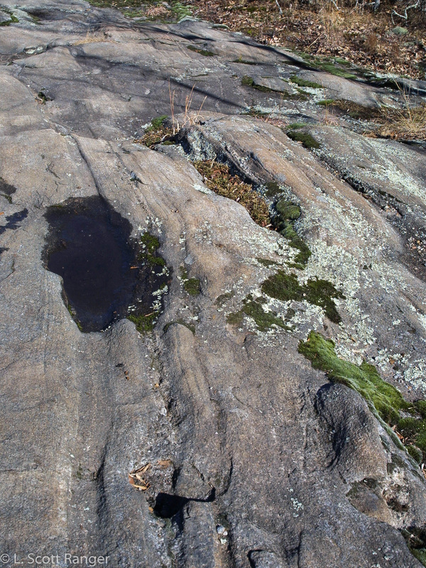
Ropes Creek amphibolite exposure atop Little Kennesaw Mountain
|
I'm very familiar with gneiss from my youth and first geology courses in southern California where it is abundant and where I became enamored with very old rock like the Paleoproterozoic Mendenhall gneiss. So every rock I see has the gneiss banding.
This matches most of my observations and for a time I take the map at its word and consider all the rocks of the mountain to be the same. It takes a number of years of wandering the mountain for me to make note of the scattered areas of dark rock mixed in with the light rock and realize they are not the same. Some of the dark rock occurs at the summit of the mountain in big slabs as the photo on the left shows. Along the slopes, especially the southeastern, there are many boulderfields. Most boulders are the light-colored rock, but mixed in with them are a significant number of darker rock. Since these boulders didn't roll uphill and the Pleistocene glaciers never reached this far south to push them up, the dark boulders must lie where they formed and were unearthed by millennia of erosion. This is my first area of confusion about the geology of the mountain. My Georgia house is located just east of Bells Ferry Road northeast of the mountain very close to the "approximate or transistional" contact between the gneiss and amphibolite. No rock of any kind can be found in my neighborhood as we sit atop a ~10 meter thick layer of Georgia red clay colored saprolite. About 1.5 meters below the current graded surface is a lens of light gray very fine-grained clay that acts as a barrier to surface water. I've always interpreted that as the remnants of Kennesaw gneiss while the Georgia red clay is the amphibolite. |
Amphibolite (metabasalt)
At this point in my life wanderings, I'd never encountered amphibolite and certainly don't remember it from my college geology courses, even if it was presented! That means it's time to do some learning.
The word comes from the Greek αμφιβολος amphibolos, which means ambiguous, given by French minerologist René Just Haüy (1743-1822) for its resemblance to augite.
Amphibolite rock contains minerals in the amphibole group (that names the rock), especially hornblende, in nearly equal proportion to plagioclase feldspars and biotite mica but with very little to no quartz. It forms in a wide pressure and temperature regime from ~500 to nearly 800°C and pressures from ~2 to 7 kbar (0.2 to 7 GPa).
Amphibolites form in Barrovian metamorphism where continents are converging (crashing together). In our case, this happened when Gondwanaland (what is now Africa) collided with Laurasia (what is now North America) to form the supercontinent Pangaea. The Proto-Tethys Sea between them had a spreading center very similar to the mid-Atlantic ridge. Here, large amounts of basalt erupted onto the floor of the ocean. As the two supercontinents collided, these rocks were subjected to heat and pressure in Barrovian metamorphism and changed into amphibolite.
It seems there were also some island-arc volcanics (also called volcanic arc) out in front of the advancing Gondwanaland. The brittle ocean floor breaks, volcanoes erupt, islands form. We can see this easily today with the Lesser Antilles and the Aleutian chain. These form when ocean crust collides with continental crust and is subducted underneath the continent. Some of the subducted material heats to the melting point and forms plumes of magma that rise. Where they break through the surface volcanoes erupt.
This means the dark gneiss of Kennesaw Mountain is actually old ocean bottom!
Amphibolite seems to have fallen out of favor as it refers to the product of a specific metamorphic environment. It has been replaced by the descriptive term metabasalt. It refers to the protolith (ancestral rock) of amphibolite, basalt, that metamorphosed into a schist or gneiss.
Watch out fort the dark rocks!
Be very careful about deciding if a rock is dark or not without closely examining it. Here in the PIedmont, nearly all of our rocks host an incredible flora of lichens that cover the rock that one must look under. Manganese leaches out from the rocks and is deposited on the surface over long periods of time (we've had some 200 million years of weathering here!) making it look very dark. Kennesaw Mountain is a National Park and breaking rocks is illegal, so one must search hard to find actual rock surface to examine.
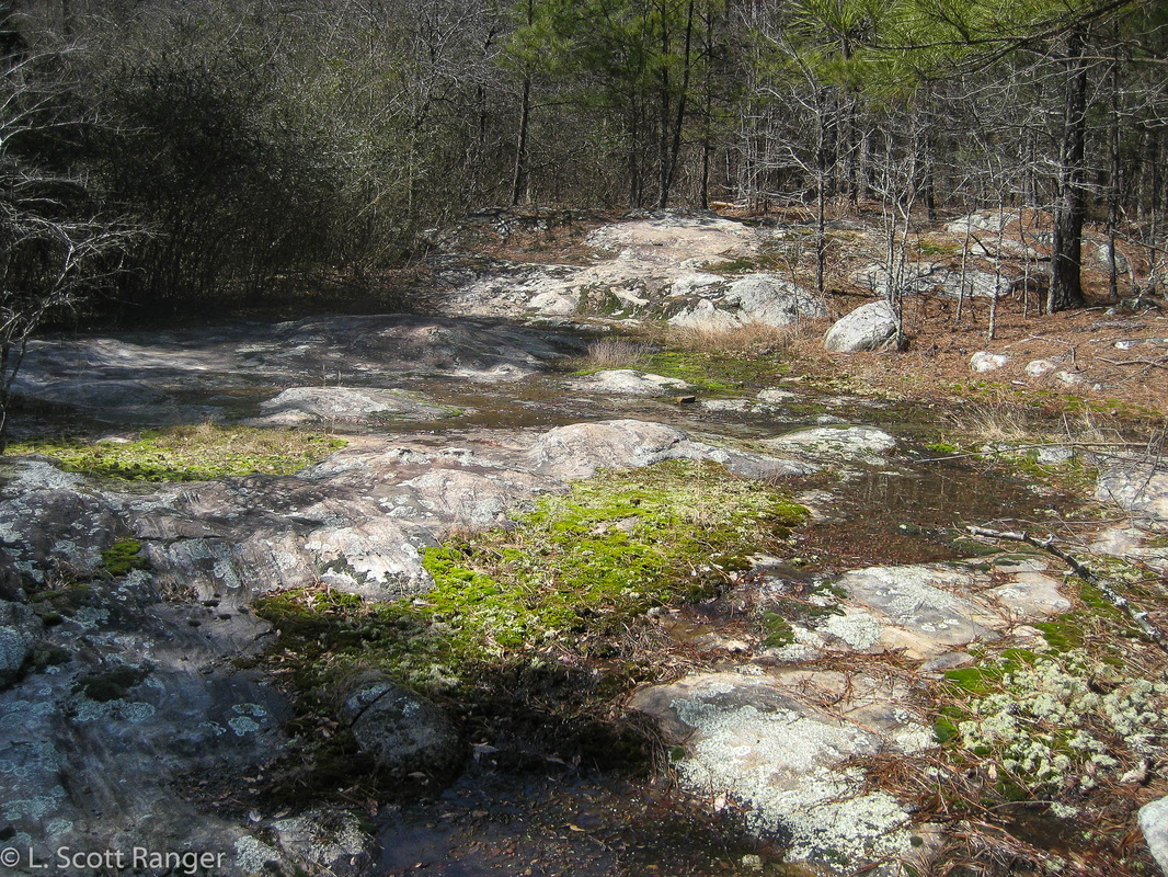
Ropes Creek metabaslt outcrop on the Camp Brumy Trail just east of the base of Pigeon Hill
For the next chapter of the story, migmatite, click here.